
Introduction
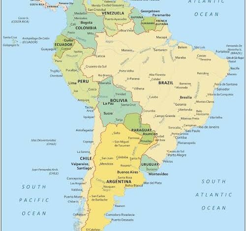
A South America map is a useful way to understand one of the world’s most geographically diverse continents. From the Andes Mountains and the Amazon Rainforest to the wide plains, deserts, rivers, and coastal regions, South America contains an extraordinary variety of landscapes.
A good map makes it easier to understand where countries are located, how they connect with one another, and where important geographical features can be found. Students, travelers, researchers, and geography enthusiasts often use maps to explore the continent and learn more about its countries and natural landmarks.
South America is located mainly in the Western Hemisphere and is bordered by the Pacific Ocean to the west and the Atlantic Ocean to the east. Its northern regions connect geographically with Central America, while its southern areas extend toward the waters surrounding Antarctica.
Countries Shown on a South America Map
One of the most important purposes of a South America map is identifying the continent’s countries. South America includes 12 independent countries, along with several territories.
The countries are:
- Argentina
- Bolivia
- Brazil
- Chile
- Colombia
- Ecuador
- Guyana
- Paraguay
- Peru
- Suriname
- Uruguay
- Venezuela
Brazil is the largest country in South America by both area and population. It occupies a large portion of the eastern and central part of the continent.
Other countries vary considerably in size and geography. Chile, for example, stretches along much of the western edge of the continent, while Ecuador is located near the northwestern region.
Looking at these countries on a map helps students understand their relative positions and borders.
The Andes Mountains
One of the most noticeable geographical features on a South America map is the Andes mountain range.
The Andes extend along the western side of the continent through several countries. They are among the world’s longest continental mountain ranges and include some of South America’s highest peaks.
The mountains influence climate, transportation, agriculture, and settlement patterns across the region.
Countries such as Chile, Argentina, Peru, Bolivia, Ecuador, Colombia, and Venezuela have areas associated with the Andes. A physical map can show how this enormous mountain system extends across the continent.
The Amazon Rainforest
Another major feature visible on many South America maps is the Amazon Basin and the Amazon Rainforest.
The Amazon Rainforest covers a huge area, with the largest portion located in Brazil. It also extends into several neighboring countries.
The region contains enormous biodiversity and is associated with one of the world’s most important river systems. The Amazon River and its tributaries form an extensive network across northern South America.
A physical map can help explain the relationship between the Amazon River, surrounding rainforest, mountains, and lowland regions.
Major Rivers
South America has many important rivers, and maps make it easier to understand their locations.
The Amazon River is the continent’s most famous river and is one of the world’s largest river systems. Other important rivers include the Orinoco, Paraná, Paraguay, and Uruguay rivers.
Rivers have historically played an important role in transportation, agriculture, trade, settlements, and ecosystems.
When studying a South America map, identifying major rivers can provide a better understanding of how different geographical regions are connected.
South America’s Oceans and Coastlines
The continent has extensive coastlines along two major oceans.
The Pacific Ocean borders the western side of South America, while the Atlantic Ocean borders the eastern side. The Caribbean Sea is located to the north of the continent.
The shape of the coastline is especially interesting when viewed on a detailed map. Chile has a long and narrow territory along the Pacific coast, while Brazil has a very large Atlantic coastline.
Coastal geography has influenced the development of major cities, ports, fishing communities, and trade routes.
Climate Regions
A South America map can also help explain the continent’s different climate zones.
Northern South America generally experiences tropical conditions, particularly around the Amazon region. Areas farther south contain temperate climates, while high mountain regions can have much colder conditions.
The Atacama Desert in northern Chile is one of the driest places on Earth. In contrast, tropical rainforest areas receive substantial rainfall.
Elevation also plays an important role. Temperatures can change considerably between lowland and high-altitude areas, particularly in the Andes.
Major Cities
Maps are useful for locating major South American cities. Some of the continent’s best-known urban centers include São Paulo, Rio de Janeiro, Buenos Aires, Lima, Bogotá, Santiago, Caracas, Quito, and La Paz.
These cities are located in very different geographical environments.
For example, Lima is situated on the Pacific coast of Peru, while La Paz is located high in the Andes region. Buenos Aires lies near the Atlantic coast, and Bogotá is located in the mountains of Colombia.
Studying city locations alongside physical geography helps explain why settlements developed in particular areas.
Political Maps and Physical Maps
There are different types of maps, and each serves a different purpose.
A political South America map focuses primarily on countries, borders, capitals, and cities. This type of map is especially useful for students learning the names and locations of countries.
A physical map focuses on natural features such as mountains, rivers, deserts, plains, and forests.
A combination map can provide both types of information. Depending on the purpose of your research, you may want to use a political map, physical map, or both.
Why South America Maps Are Useful for Students
Maps are an important educational tool. Students can use them to learn geography more effectively because visual information can make relationships between locations easier to understand.
A South America map can help students memorize country positions, identify capitals, trace rivers, locate mountain ranges, and understand different physical regions.
Teachers may also use maps for classroom activities, geography quizzes, projects, and presentations.
Instead of memorizing information separately, students can use a map to connect geographical facts together.
Using a Map for Travel Planning
Travelers can also benefit from studying a map before visiting South America.
The continent is enormous, and countries can have very different climates, landscapes, cultures, and transportation systems. A map can help travelers understand distances between destinations and plan a logical route.
For example, someone interested in visiting the Andes may choose destinations in countries such as Peru, Bolivia, Chile, Ecuador, or Argentina. A traveler interested in beaches might focus on coastal areas.
Understanding geography before traveling can make planning easier and provide a better appreciation of the places being visited.
Conclusion
A South America map provides a simple but powerful way to explore the continent’s geography. It shows the locations of countries, cities, mountains, rivers, deserts, forests, and coastlines while helping people understand how these features relate to one another.
From the Andes Mountains in the west to the Amazon Basin in the north and the vast Atlantic coastline in the east, South America offers remarkable geographical diversity.
Whether you are a student studying world geography, a traveler planning a journey, or simply someone interested in learning about different parts of the world, using a detailed map can make South America’s geography easier and more interesting to understand.
You May Also Read

One Comment